
Photo: A map of Tennessee’s congressional districts as drawn by legislative Democrats. (Map courtesy of Tennessee Senate Democratic Caucus)
By Sam Stockard [The Tennessee Lookout CC BY-NC-ND 4.0] –
Tennessee Democrats are submitting a congressional redistricting map that keeps Davidson County whole and puts communities of interest together, but at least one state senator is pouring cold water on the plan.
The proposal is likely to draw heat, not just because Republicans control the House and Senate, but because it draws a new 4th Congressional District and puts Republican Congressman Scott DesJarlais of Jasper in a realigned 6th Congressional District with Republican Congressman John Rose of Cookeville.
“I can tell you, that’s not gonna happen,” state Sen. Mike Bell, co-vice chairman of a Senate redistricting committee, said Tuesday. “I don’t know anything else about the map, but I can tell you that’s not gonna happen.”

Under the Democrats’ plan, the new 4th District would take in Williamson, Rutherford and Wilson counties and the cities of Hendersonville and Spring Hill, giving it a population of 768,026, .10% from the optimum number. A deviation of .75% is allowed from 767,871.
The proposal for the 5th District would keep Davidson County whole, as Democratic Congressman Jim Cooper has requested, and add La Vergne from Rutherford County and parts of Goodlettsville and Millersville from Sumner County.
Democrats contend it is not a partisan proposal but creates a better map by placing communities with similar growth and transportation needs in the same congressional district.
It also addresses concerns raised by Republican Congressman Mark Green of Montgomery County, who has been frustrated by the possibility that Davidson County would be split into a new district taking in Williamson County and other counties, creating competition for him in the 7th Congressional District.
Green isn’t commenting publicly on redistricting maps, his press secretary said Tuesday.
**** CLICK HERE to support Conservative Journalism in Tennessee. We bring you stories like this without your support!
So far, neither Senate or House Republican map makers have unveiled any proposals, even though a new district map is to be presented in January when the Legislature convenes.
Democrats held listening meetings across the state and said they heard similar requests from people who asked that communities with similar interests be kept together.
“People wanted their elected officials to be responsive to the needs of their community. So, in addition to drawing districts that are nearly identical by population, we are proposing districts with deep community connections and shared needs — like housing, healthcare, education, transportation and job creation,” said Sen. Raumesh Akbari, a Memphis Democrat serving as co-vice chair of the Senate redistricting committee.
Democratic Sen. Jeff Yarbro, the Senate minority leader, pointed out that Williamson, Rutherford and Wilson counties in the I-840 corridor deal with the same growth, infrastructure and service challenges and need regional coordination.
“The future of these communities is inherently linked together regardless of county lines or city lines,” Yarbro said in a statement.
The Legislature is required by law to draw political boundaries for each of the state’s nine congressional districts before the 2022 election cycle, along with new district lines for state House and Senate seats. The maps must use population data from the 2020 federal census.
“We know Republicans are cutting deals on district lines behind closed doors and playing partisan politics with their maps, but that’s not going to stop us from engaging Tennesseans in a good-faith process,” said Rep. Vincent Dixie of Nashville, chairman of the House Democratic Caucus.
Democratic Rep. John Ray Clemmons of Nashville has already raised objections to a “concept” drawing of House district maps that placed his home in the same district with Democratic Reps. Mike Stewart of Nashville and Jason Potts of Antioch. Potts is not planning to run for re-election.
People wanted their elected officials to be responsive to the needs of their community. So, in addition to drawing districts that are nearly identical by population, we are proposing districts with deep community connections and shared needs–like housing, healthcare, education, transportation and job creation. – – Sen. Raumesh Akbari, D-Memphis
Republicans are playing it close to the vest and not giving the public a glimpse of their designs.
Regardless, Bell said Tuesday he believes the maps drawn by Republicans will stand up in court and give Tennesseans fair representation. He had not seen the Democrats’ proposal.
“I appreciate the Democrats’ input, but I would point out that prior to the map that the Republicans submitted in 2011, the previous four decades of redistricting maps that have been drawn by the Democrats were all successfully challenged in court,” Bell said. “The one we submitted in 2011 was the first one in four decades that was not successfully challenged in court.”
That proposal survived a legal challenge, he pointed out.
Scott Golden, chairman of the Tennessee Republican Party, said Tuesday he had not seen the Democrats’ proposal. But he said the process for legislators redrawing district maps is moving along at the normal pace, with the legislation likely to be unveiled in January.
A spokeswoman for the House Republican Caucus did not respond Tuesday when asked whether leaders could estimate a time frame for making their map public.
Golden did not speculate on whether the Democrats’ map would be acceptable.
“Throughout this year, everybody’s had their pens and pencils out drawing congressional maps to get to the optimum number,” Golden said.
The Tennessee Republican Party doesn’t have anything to do with the redistricting, he added, noting he has “full confidence” in legislators to propose new maps.
Golden acknowledged it is an “inherently political process” and lawmakers have had multiple conversations among themselves and members of Congress.
“Everybody is looking for the most optimum way to draw it that ensures it’s a fair and transparent process,” he said.
Redistricting committees of the Senate and House are accepting map proposals from groups and individuals across the state.

The Senate Democrats’ proposal:
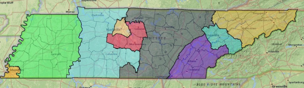
1st Congressional District: Includes 11 counties from the current map, Carter, Cocke, Greene, Hamblen, Hancock, Hawkins, Jefferson, Johnson, Sullivan, Unicoi and Washington counties and adds Claiborne, Grainger and Union counties and part of Campbell just west of LaFollete.
2nd Congressional District: Includes Knox, Anderson and Sevier counties and the city of Maryville in Blount County.
3rd Congressional District: Would move the district into the state’s southeast corner, instead of the current shape, which extends from downtown Chattanooga to Kentucky. It would take in Bradley, Hamilton, Loudon, McMinn, Meigs, Monroe, Polk, Rhea and Roane counties and part of Blount. Scott, Campbell, Union, Morgan and Anderson counties would be removed.
4th Congressional District: Would contain Williamson and Wilson counties, most of Rutherford County, except La Vergne, and the cities of Hendersonville and Spring Hill.
5th Congressional District: Would take in all of Davidson County, La Vergne in Rutherford and Goodlettsville and Millersville in Sumner County. Dickson and Cheatham counties would be removed.
The 6th Congressional District would be largely rural, including Bledsoe, Cannon, Clay, Coffee, Cumberland, DeKalb, Fentress, Franklin, Grundy, Jackson, Lincoln, Macon, Marion, Morgan, Overton, Pickett, Putnman, Scott, Sequatchie, Smith, Trousdale, Van Buren, Warren and White counties and portions of Sumner and Campbell counties. Wilson County would be removed.
7th Congressional District: Would include Clarksville and Columbia but would shift away from West Tennessee with the Tennessee River serving as a boundary. It would take in Bedford, Cheatham, Dickson, Giles, Hickman, Houston, Humphreys, Lawrence, Lewis, Marshall, Maury, Montgomery, Perry, Robertson, Stewart and Wayne counties and most of Maury and Hardin counties, in addition to all of White House, which straddles the Robertson-Sumner line.
8th Congressional District: Would be bordered by the Tennessee River on the east and Mississippi River on the west side, taking in Benton, Carroll, Chester, Crockett, Decatur, Dyer, Fayette, Gibson, Hardeman, Haywood, Henry, Lake, Lauderdale, Madison, McNairy, Obion and Tipton counties, plus parts of Hardin County and the cities of Arlington, Collierville, Germantown, Lakeland and Millington in Shelby County. It would drop parts of East Memphis.
9th Congressional District: Takes in the entire city of Memphis, in addition to Bartlett and some parts of unincorporated Shelby County.


Sam Stockard is a veteran Tennessee reporter and editor, having written for the Daily News Journal in Murfreesboro, where he served as lead editor when the paper won an award for being the state’s best Sunday newspaper two years in a row. He has led the Capitol Hill bureau for The Daily Memphian. His awards include Best Single Editorial from the Tennessee Press Association. You can contact Stockard at sstockard@tennesseelookout.com.

One Response
Democrats will do anything to get and keep power. Democrats today are Communist. I don’t care if they are city, county, state or Federal. They all have an agenda to over through this country and make it a communist nation. They will do it state by state if they have to.