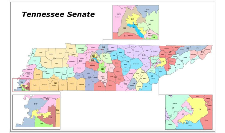
Image: Proposed Tennessee Senate redistricting map for 2022. Image Credit: Tennessee Senate
The Center Square [By Jon Styf] –
The recommended map for Tennessee’s state Senate districts was presented by the Senate Ad Hoc Committee on Redistricting on Thursday with far less objection than the maps for the Tennessee House and congressional districts.
The Senate map (Senate Bill 780/House Bill 1037) does not pair incumbent legislators and had nine counties that were split into two or more districts. The Senate map and congressional map (Senate Bill 781/House Bill 1034) were approved by the committee and the companion bills containing the same maps are scheduled to be heard Tuesday by the Senate Judiciary Committee and House State Government Committee.
All three maps are expected to reach the full Senate by Jan. 20, Senate Democrat Caucus Press Secretary Brandon Puttbrese said.
Sen. Jack Johnson, R-Franklin, presented the Senate map, and said Democratic leadership previously split Davidson County into two congressional districts in 1992 and 2002 during the redistricting process, which the state is required to go through every 10 years after the U.S. census.
Johnson said the population growth in the state was uneven and everything compressed toward middle Tennessee so those districts needed to become smaller geographically while rural districts grew geographically because of population shifts.
“Despite a compressed timeframe due to the late release of census data, the committee conducted an open and transparent process that solicited and considered input from all Senators and the general public,” Tennessee Lt. Gov. Randy McNally said in a statement. “The recommended maps are fair and legal, disturb no currently serving legislator and preserve, as much as possible, current district composition. Despite challenging and contradictory state and federal mandates, this committee managed to keep both population deviation and county splits to historic lows. An excellent work product to hand off to the Senate Judiciary Committee as this process continues.”
Sen. Jeff Yarbro, D-Nashville, was the lone dissenting vote on the Senate map approval and the only Democrat present at the meeting. Committee member Sen. Raumesh Akbari, D-Memphis, was not present.
Yarbro said the Senate map was a “great starting point” and “it doesn’t seem to be motivated by any pettiness” such as the other maps presented, but he still believed the committee should have more time discussing the new maps and getting feedback.
The maps were first presented publicly near the start of the meeting, and the committee voted on the maps less than 30 minutes later.
***Click HERE to support Conservative Journalism in Tennessee. We can’t bring you stories like this without your support!***
“We wanted to allow as much time as possible for public comment,” Johnson noted, pointing to when that occurred before the recommended maps were created. “We need to get it out of the hands of this committee and into the hands of the General Assembly.”
After approving the Senate maps, the committee discussed the recommended congressional map, which would have three different districts representing Davidson County surrounding Nashville. Yarbro, who represents Nashville, called the maps an “aggressive gerrymander.”
“I represent, right now, one of the most narrow geographical bands of any of us in the state Senate,” Yarbro said. “About 200,000 people in Davidson County. If this is enacted, the people in my small district will be in common districts with folks from Decatur County in west Tennessee to the Appalachian Mountains. That is an absurdity. I miss my family in Decatur County and would like to see them more, but it doesn’t make any sense that we would be in the same congressional district.”

About the Author: Jon Styf, The Center Square Staff Reporter – Jon Styf is an award-winning editor and reporter who has worked in Illinois, Texas, Wisconsin, Florida and Michigan in local newsrooms over the past 20 years, working for Shaw Media, Hearst and several other companies. Follow Jon on Twitter @JonStyf.


One Response
Our county has moved from district 26 to 25 and that district looks totally screwy! One long narrow band running from Perry county to Lake county makes no common sense. It is now a totally different district. We are now with Madison County. Where was our senator when this was done, sleeping?